


Florac rando soupe

MMarie
User
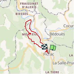

Length
11 km

Max alt
762 m

Uphill gradient
331 m
Km-Effort
15.5 km

Min alt
538 m

Downhill gradient
331 m
Boucle
Yes
Creation date :
2014-12-10 00:00:00.0
Updated on :
2014-12-10 00:00:00.0
3h40
Difficulty : Easy

FREE GPS app for hiking
 SityTrail
IGN / Geographical institutes
SityTrail Plus
The world is yours!
About
Trail Walking of 11 km to be discovered at Occitania, Lozère, Florac Trois Rivières. This trail is proposed by MMarie.
Positioning
Country:
France
Region :
Occitania
Department/Province :
Lozère
Municipality :
Florac Trois Rivières
Location:
Florac
Start:(Dec)
Start:(UTM)
547395 ; 4908024 (31T) N.
Comments